Prediction Team 3
Research 3-1
Research 3 shows how it changes by switching the location of urban and water bodies.
1) the case that urban area is surrounded by water bodies
2) the case that water bodies are surrounded by urban area
To compare two cases, lm is specified as 25 and we use ‘Urban and Built-Up Land’ and ‘Water Bodies’ index from ‘available land types in USGS LANDUSE option’.
0-24
Water Bodies
25-74
Urban
75-99
Water Bodies
0-24
Urban
25-74
Water Bodies
75-99
Urban
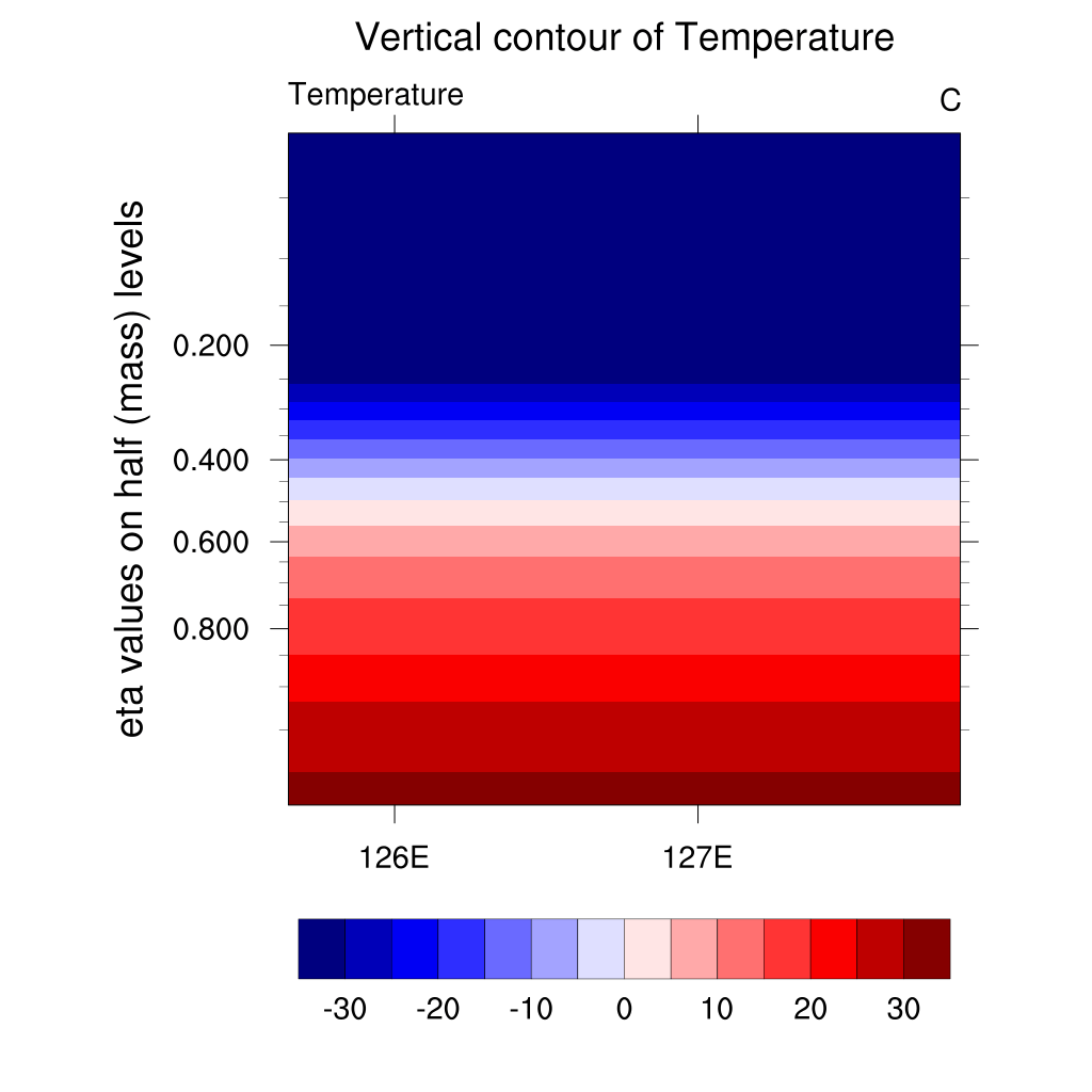
Temperature

1. Urban in the middle

2. Urban in the edges
“Thinner atmosphere layer with high temperature in Case 1”
In the vertical contour of Temperature graph above, the air that was warmed during the day cools down quickly. The air over the water cools faster than the air over the city, leaving a hot air mass above the city. In case 1, a layer of hot air cools and disappears from the outside. while, two hot air masses start to cool down only on one side in case 2. A temperature inversion starts to occur at time step 15 which means 10:30 pm. Comparing the two graphs, the thickness of the dark colored air layer with high temperature is slightly thinner when the city is in the middle. Also, you can see the hot air layer cooling relatively faster.
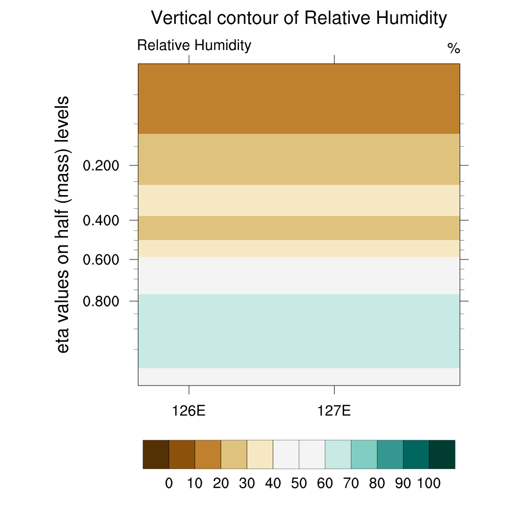
Relative Humidity

1. Urban in the middle

2. Urban in the edges
“Higher relative humidity in Case 2”
First, humidity increases at the water surface and then converges towards the urban in case 1. However, you can see the humidity increasing toward the outside where the water bodies are located after time index 14 which means 10:00 pm. Similarly, the humidity at the water surface in case 2 is higher than the urban surface at the beginning. However, the humidity above the urban is higher than the water bodies at around 0.800. As time step increases, a layer of air with high humidity at the surface spread outsides.
Through the difference in thickness of the layer with high humidity below 0.800, it is shown that the urban area is less humid in case 1 than case 2.
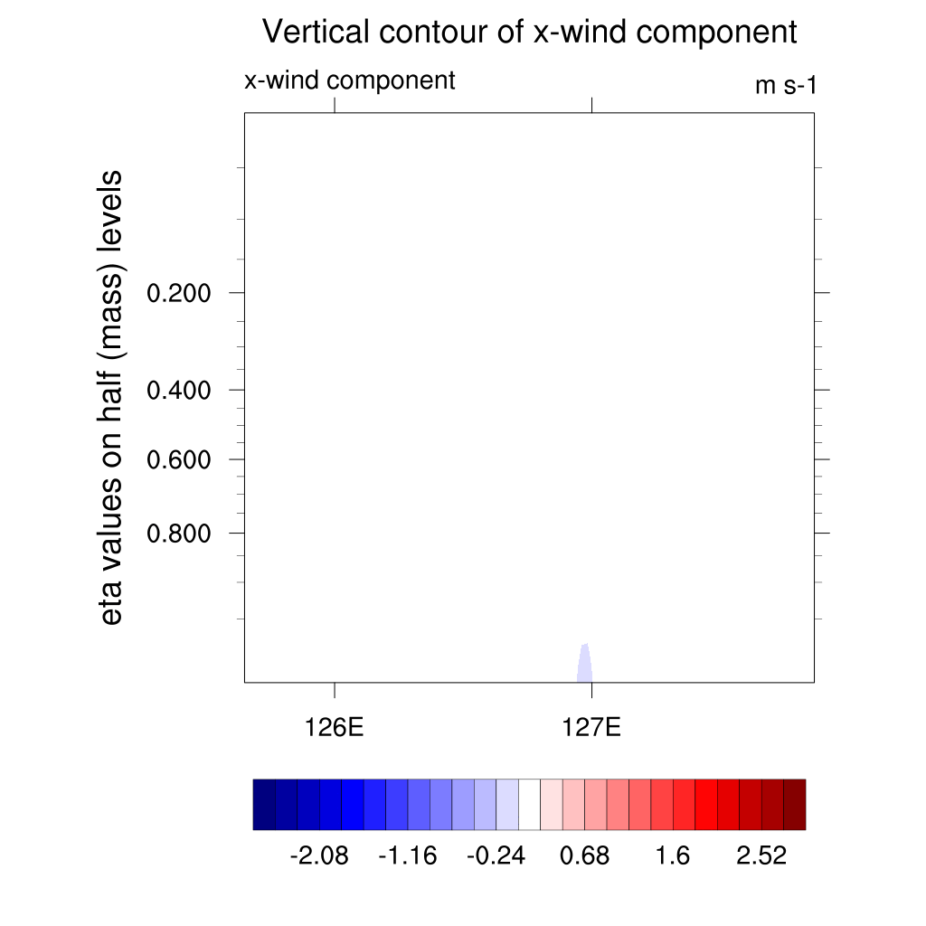
U-Wind

1. Urban in the middle
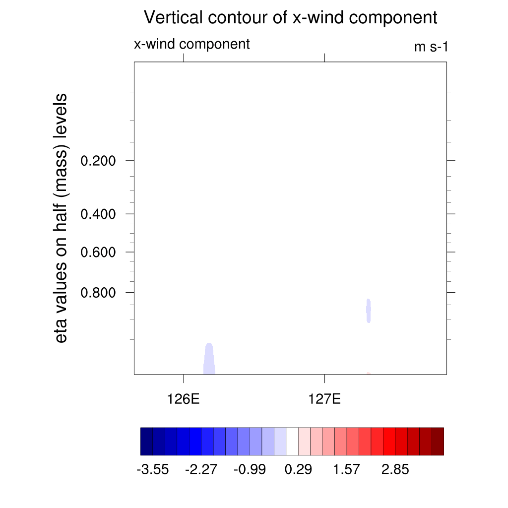
2. Urban in the edges
“U-winds in opposite directions in two cases”
The variable is the x-wind component in the two graphs above. So, the part with a red positive value means the wind blowing from west to east, and the part with a blue negative value means the wind blowing from east to west. In case 1, winds that converge toward the center are formed in the beginning, but after time index 13 which means 9.30 pm, the air spreads outward starting from the center. In contrast, in case 2, the air diverges in the beginning, but the direction of wind changes from outside to inside after time index 13 like case 1. After, the air blows to the center from time index 14 which refers to 10:00 pm. As a result, we can see that the wind initially blows from the water to the city and then changes direction from the urban area to the water bodies.
W-wind

1. Urban in the middle

2. Urban in the edges
“Stronger W-wind in case 1”
The variable is a z-wind component in the graph above. So, the part with a red positive value means that the air is rising from bottom to top, and the part with a blue negative value means that the air is descending from top to bottom. As the time step increases, the air with a strong upward current appears to move left and right in both graphs. In Case 1, z-wind is formed at the where two different land types meet. Over time, the updraft becomes stronger inside the city. After time step 14 which refers to 10 pm, the red-colored part with strong updraft moves outward. On the other hand, in case 2, the part with strong updraft formed at the where two land types meet gradually moves outward and changes direction to the center after time index 12 which means 9:00 pm. Because z-wind is a wind that blows up and down on the graph, the wind at high latitudes is affected by the wind generated at the land surface. In short, strong updraft moves from the water towards the city and then the direction is reversed after 6-7 hours.
Wind Vector

1. Urban in the middle

2. Urban in the edges
“Opposite convergence and divergence of the air”
These vector plot is drawn using ua and wa variables. Focusing on the changes that occur on the land surface, it is shown that the air bodies diverges over water bodies and converges in the center of the urban area in case 1. And this time, the collected air spreads outward from the city center. On the other hand, in case 2, the air over the water bodies spreads to the city, then gathers and mixes over the water again after reflected from both boundary. In other words, the wind initially blows from the water to the city, but the wind flow changes at time step 13 which means 9:30 pm. Therefore it is shown that the convergence/divergence of the air changes.
Conclusion
0-24
Water Bodies
25-74
Urban
75-99
Water Bodies
The heat island effect is mitigated when the urban area is in the middle. Through two graphs with wind and temperature variables, the results were derived that the air over the water bodies cools faster than the air over the urban area, and the cool wind blowing from the water bodies makes the urban area cool. At this time, it was found that cooling the urban in the middle was faster and more effective than cooling the urban in the edges. Considering the fact that low relative humidity affects the heat island effect, it can be seen that the case that the urban area is located in the center is more pleasant and lower the heat island effect because the air layer with high humidity is thinner than the case that the urban area is located in the edges.
Research 3-2
Research 3-2 shows how it changes by changing the size of urban and water bodies.
A) Water:Urban:Water = 2:1:2 case
B) Water:Urban:Water = 1:3:1 case
To compare two cases, lm of two cases is designated as 10 and 30 separately and we use ‘Urban and Built-Up Land’ and ‘Water Bodies’ index from ‘available land types in USGS LANDUSE option.
0-39
Water Bodies
25-74
Urban
60-99
Water Bodies
0-19
Water Bodies
20-79
Urban
80-99
Water Bodies
Temperature
A. Large Water Bodies

B. Small Water Bodies
“Faster cooling in case A”
Although the size of the warm air layer that is initially formed is the same, the air cools faster over the water. So, overall, the urban cools down quickly in case A, where the urban area is small. On the other hand, in case B, a very large hot air mass is formed due to the heat island phenomenon. The temperature inversion phenomenon is also stronger in case A, where the proportion of water is larger.
Relative Humidity
A. Large Water Bodies

B. Small Water Bodies
“High humidity in Case A”
Because the size of the water is different in the two cases, the relative humidity distribution is clearly different. In particular, in case A, the dark colored air layer with high humidity is quickly formed and spreads left and right. After the air layer with high humidity is formed at 0.800 eta above the urban, it does not disappear and maintains high humidity. On the other hand, in case B, the white colored wide layer with relatively low humidity is formed above the urban, and then the humidity gradually increases. Also, it can be seen that air layers with similar humidity are formed horizontally in case B.
U-Wind
A. Large Water Bodies

B. Small Water Bodies
“Early x-wind direction change in case A”
In case A, Because the area of the urban is small, x wind is created and the wind changes immediately at time step 9 which means 7:30 pm in case A. On the other hand, in case B, the area of the city is large, so the x-wind formed at where two land types meet spreads widely. Afterwards, the direction changes at time step 15 which refers to 10:30 pm.
W-Wind

A. Large Water Bodies
B. Small Water Bodies
“Stronger updraft in Case A”
The most visible thing is that the two strong z-wind currents are large and high in case A. They spread towards to the boundary quickly after meeting at the center at time step 9 which means 7:30 pm. On the other hand, in case B, the direction change starts from time step 15 which refers to 10:30pm and two updrafts are getting weaker.
Wind Vector

A. Large Water Bodies

B. Small Water Bodies
“Rapid air convergence and divergence in case A”
In case A, air convergence and divergence occur rapidly. It means that air flow changes rapidly because the urban area is very small. Generally, the wind patterns, except for speed, are similar for case A and B.
Conclusion
0-39
Water Bodies
25-74
Urban
60-99
Water Bodies
The larger the urban area surrounded by water, the greater the effect of mitigating the heat island phenomenon. When the water bodies occupy a larger area of the land surface, the winds blowing from the water into the city are stronger, cooling the city faster. Therefore, expanding the area of water surrounding a city can effectively mitigate the heat island effect.